Serverseitiges JavaScript und GIS
Mit Node.js und npm die Welt beherrschen
Christian Mayer und Marc Jansen
FOSSGIS 2015, Münster, 12.03.2015
Gliederung
- Über…
- Node.js und Freunde
- Beispiele und Highlights
- Fazit
Christian Mayer

- Softwareentwickler & -architekt
- Vornehmlich im GIS-Bereich
- Open Source Enthusiast
- Kernentwickler GeoExt
- OpenLayers, GeoTools, uvm.
- Sprecher bei nat. und internat. Konferenzen (FOSS4G, FOSSGIS, SVG Open)
- OSGeo Foundation Charter Member

Marc Jansen


- Seit 2007 Entwickler / Projektleiter bei terrestris
- Kernentwickler und PSC Mitglied GeoExt
- Kernentwickler OpenLayers
- Buchautor "OpenLayers"
- OSGeo Foundation Charter Member
terrestris
- terrestris.de
- OpenSource GIS aus Bonn
- Entwicklung, Projekte & Support/Schulung
- Beratung, Planung, Implementierung & Wartung
Über diesen Vortrag
- Überblick serverseitiges JS ✔
- Beispiel und Module ✔
- Ziel: Interesse wecken ✔
- Komplettlösung aller Probleme ✗
- …aber das hatten Sie natürlich auch nicht erwartet 😄
Warum Node.js?
Warum nicht!
Node.js
A platform built on Chrome's JavaScript runtime for easily building fast, scalable network applications. Node.js uses an event-driven, non-blocking I/O model that makes it lightweight and efficient, perfect for data-intensive real-time applications that run across distributed devices.Quelle: https://www.openshift.com/products/technologies
Node.js
- Serverseitige JavaScript Plattform
- Verarbeitung von großen Datenmengen durch nicht blockierendes IO-System
- Event-basiert
- Ideal für Webanwendungen
- Open Source (MIT)
- Aktuelle Version 0.12.0 (06.Feb.2015)
JavaScript…
…auf dem Server
Hello World
console.log("Hello, World");
>> node hello-world.js
>> Hello, World
Node.js - Beispiel
Einfache HTTP-Schnittstelle (Port 8888)
// native dep
var http = require('http');

http.createServer(function (req, res) {
  res.writeHead(200, {
    'Content-Type': 'text/html'
  });
  res.write('Hallo FOSSGIS 2015');
  res.end();
}).listen(8888);

Installation
- Installer für Windows
- Viele Paketmanager stellen Pakete bereit
- from source
- via nvm (node version manager)
>> nvm ls-remote        # Welche Versionen gibt es?
>> nvm use v0.12.0      # Verwende nun v0.12.0
npm
- Paketmanager für JavaScript
- Standard Paket-Repository für Node.js (Seit Node.js Version 0.6.3 Teil der Installation)
- Einfache Installation von Software-Pakten
- Automatische Auflösung von Abhängigkeiten
- Defacto-Standard zur Modularisierung von JavaScript
npm facts
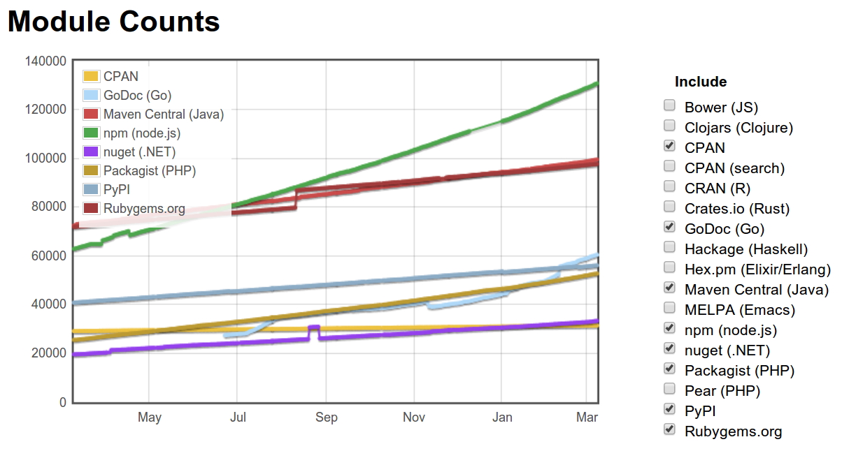
- ~ 130.000 Pakete (Anfang März 2015)
- ~ 1.000.000.000 Downloads im vergangenen Monat (Feb. 2015)
- ~ 6.400 Pakete für die Schlagwörter
mapping, map,gis,geo,osm(Anfang März 2015) - u.a. auch OpenLayers und Leaflet
- npm stellt seine eigenen Code auf npmjs.org bereit
 http://www.modulecounts.com/
npm - Installation von Paketen
>> npm install package_name # installiert lokal
>> npm install ol-app-setup -g # installiert global
>> npm install # liest package.json aus
io.js

io.js
- Fork von Node.js / npm kompatibel
- Einige Kernentwickler ↠ io.js
- Verschiedenste Gründe, u.a.
- Open Governance Model
- zu seltene Releases
- persönliche Differenzen
- Changes re-importierbar nach Node.js
- Unbedingt im Auge behalten
Mit Node.js und npm die Welt beherrschen

turf.js
Bildquelle: http://www.macwright.org/presentations/turf-geodc/grass.jpgturf.js
- JS-Bibliothek zur Geodatenverarbeitung und für räumliche Analysen
- Erschienen 2014
- Neuentwicklung, kein Port von JTS
- Native Unterstützung von GeoJSON
- Nutzbar in Client UND Server (eine Codebasis)
- Open Source (MIT)
>> npm install turf
turf.js - Funktionen (Auszug)
- Transformationen (Buffer, Merge, Union, ...)
- Measurement (Area, Envelope, Distance, ...)
- Aggregation (Sum, Average, Aggregate...)
- Classification (Nearest, Reclass, ...)
- Interpolation (TIN, Isolines, Triangle-Grid, ...)
- uvm ...
// create a geojson point object by turf wrapper ...
var point1 = turf.point([7.8, 51.8]);
// ... and buffer it
var buffered = turf.buffer(point1, 100);
Shapefile.js
- Lesen und Schreiben von Shape-Dateien
>> npm install shapefile
// 3rd party deps
var shapefile = require('shapefile');

// create a shapefile reader
var reader = shapefile.reader(
    'data/shapefile/bands.shp',
    {encoding: 'UTF-8'}
);
// read the features
reader.readHeader(function(error, header) {
    if (error) throw error;
    readFeature(reader);
});

/**
 * Reads a geojson representation of the shp features
 */
function readFeature(reader) {
    reader.readRecord(function(error, record) {
        if(record != shapefile.end) {
            console.log(record);
            readFeature(reader);
        }
    });
}
proj4
- Projektion / Transformation von Geodaten
>> npm install proj4
// 3rd party deps
var proj4 = require('proj4');

// reproject a point
var projected = proj4('EPSG:4326', 'EPSG:900913', [2,5]);
console.log(projected);
>> node proj4.js
>> [ 222638.98158654713, 557305.2572745753 ]
Web mapping Module
openlayersleaflet+ Pluginsd3+ Plugins-
ol-app-setup>> npm install ol-app-setup -g >> ol-app-setup -t /tmp/foo -v ol3 -s - Zur Entwicklung an vielen Projekten gehört Node.js fest dazu
- vgl. a. PostgreSQL: PL/v8
Was lernen wir daraus?
- Node.js & npm sind eine wunderbare Kombination
- …auch im GIS-Bereich
- …mit Stärken und Schwächen (wie immer 😄)
- …bei gleichzeitig unglaublichem Drive
- …und riesiger Entwicklergrundgesamtheit
- …also eine echte Alternative
Give it a try!
Es macht echt Spaß damit zu arbeiten
That's it
Fragen & Anmerkungen?
Impressum
Autoren
Christian Mayer
meggsimum.de
Hauptstraße 165a
67125 Dannstadt-Schauernheim
chris@meggsimum.de
meggsimum.de
Hauptstraße 165a
67125 Dannstadt-Schauernheim
chris@meggsimum.de
Marc Jansen
terrestris GmbH & Co. KG
Pützchens Chaussee 56
53227 Bonn
jansen@terrestris.de
terrestris GmbH & Co. KG
Pützchens Chaussee 56
53227 Bonn
jansen@terrestris.de
Lizenz
Diese Folien sind unter CC BY-SA veröffentlicht.
